PLEASE NOTE: This data set should be acknowledged:
Ye, N., Walker, J. P., Wu, X., de Jeu, R., Gao, Y., Jackson, T. J., Jonard, F., Kim, E., Merlin, O., Pauwels, V., Renzullo, L. J., Rüdiger, C., Sabaghy, S., von Hebel, C., Yueh, S. H., and Zhu, L., (2021). The Soil Moisture Active Passive Experiments: Towards calibration and validation of the SMAP Mission. Remote Sensing of Environment, 59(4): doi: 10.1109/TGRS.2020.3007371. |
Experiment Overview
This fourth campaign (SMAPEx-4) was conducted in the austral autumn for 3 weeks, from 1st May to 22nd May 2015, with the main objective to collect airborne active and passive microwave data, ground observations of soil moisture, and ancillary data needed for soil moisture retrievals in coincidence with SMAP coverage, providing microwave observation and soil moisture references for SMAP in-orbit validation.
Data collected during SMAPEx-4 mainly consisted of:
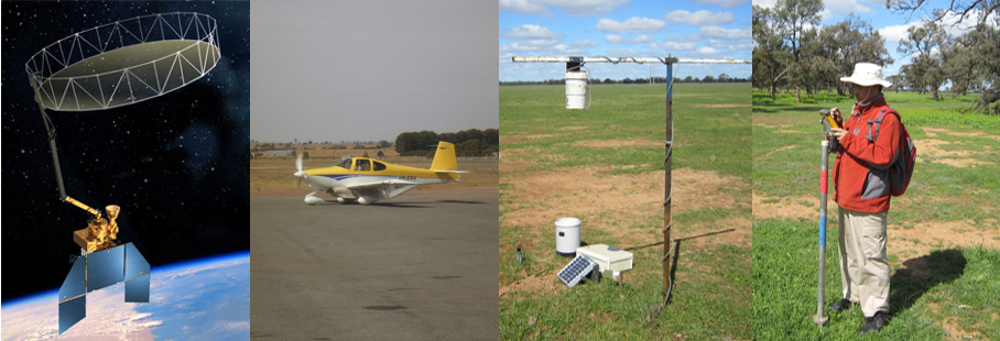
• airborne Polarimetric L-band Imaging SAR (PLIS) and Polarimetric L-band Multibeam Radiometer (PLMR) observations, together with ancillary visible, near infrared, shortwave infrared, and thermal infrared;
• continuous near-surface (top 5 cm) soil moisture and soil temperature monitoring at 35 permanent stations across the study area. Of these stations, 11 will also provide profile (0-90 cm) soil moisture and soil temperature data;
• additional intensive measurements of near-surface (top 5 cm) soil moisture spatial distribution, vegetation biomass, water content, reflectance, and surface roughness across six approximately 3km × 3km focus areas;
• intensive sampling for radar algorithm development;
• regional soil moisture across the ground sampling area; and
• high resolution soil moisture maps over a 3 km × 3 km focus area, using vehicle-based sensors including GNSS-R sensor, L-band radiometer, multispectral sensors, thermal infrared sensor, ElectroMagnetic Induction (EMI) sensor and ElectroMagnetic (EM38) soil mapping.The airborne and ground monitoring strategy followed a “nested grid” approach based on the SMAP grids. Airborne data were collected over an area conservatively covering a complete SMAP radiometer 3 dB footprint (SMAP L1B_TB product, 39 km by 47 km) for a total of 9 dates over a 3-week period. The flight area completely contained four SMAP radiometer pixels (SMAP L1C_TB product, 40 km by 40 km nominal resolution). Continuous ground permanent monitoring sites covered an entire SMAP radiometer pixel at the southwest corner, but with a denser network in two sub-areas representing pixels of the SMAP downscaled soil moisture product (SMAP L3_SM_A/P product, 9 km by 9 km). Intensive spatial monitoring concentrated on six focus areas equivalent to a SMAP radar pixels (L1C_HiRes product, 3 km × 3 km). This design allowed comparing SMAP products over the Yanco study area to airborne observations aggregated to SMAP radiometer and radar resolutions, as well as detailed validation against ground data of the airborne data at all the resolutions of the SMAP products.
Complete details on the airborne and ground sampling activities can be found in the experiment plan. The data collected can be viewed and downloaded from the menu on the sidebar. A summary of the campaign schedule is provided below.
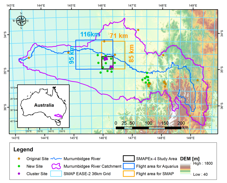
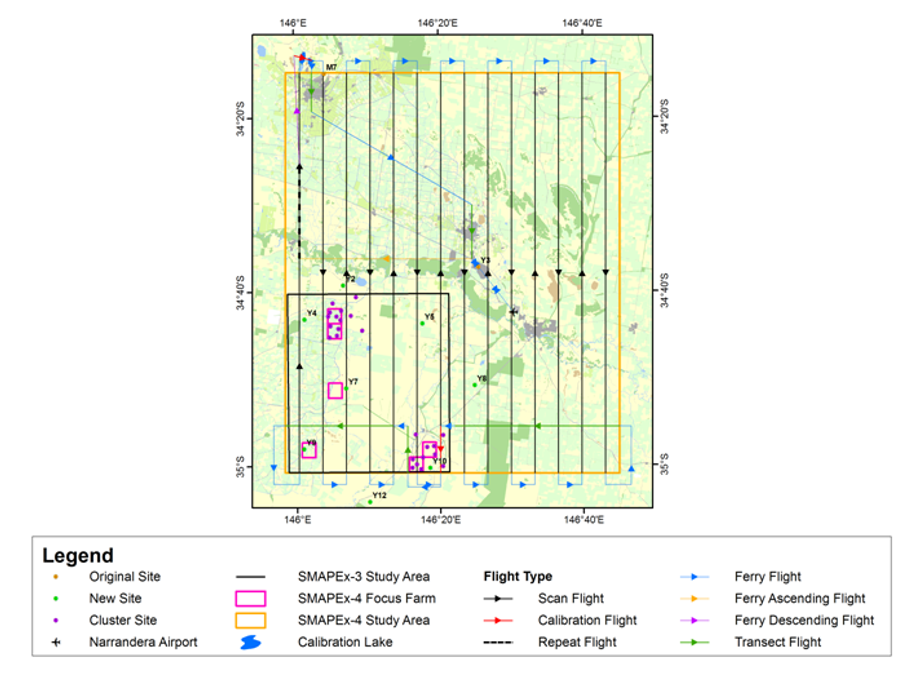
SMAPEx-4 Study Area
Two types of flights were conducted during SMAPEx-4, including flights for SMAP and flights for Aquarius, so as to provide the opportunity to compare the observations from satellites and airborne. See below the flight lines for each type:
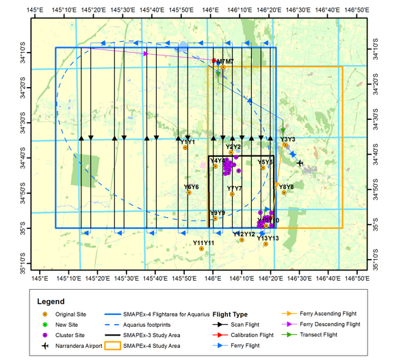
Flight lines for SMAP
Flight lines for Aquarius
Ground sampling was undertaken concurrently with the flights and mainly included intensive spatial soil moisture sampling in six focus areas, as well as the regional soil moisture sampling in SMAPEx study area. Other ground activities performed in the study area included the surface roughness sampling, gravimetric soil sampling, intensive vegetation sampling, vegetation LAI and reflectance measurements, classification of land cover and canopy height, and crop row spacing and direction, Buggy-based radiometer (Elbara), Largo, EM38, EMI, TIR, multi-spectral sensors and etc. In addition to sampling activities, the monitoring network, i.e. OzNet, SMAPEx stations, and temporary monitoring sites continued to record additional soil moisture and temperature, vegetation skin temperature, leaf wetness and rainfall data during the experiment period.
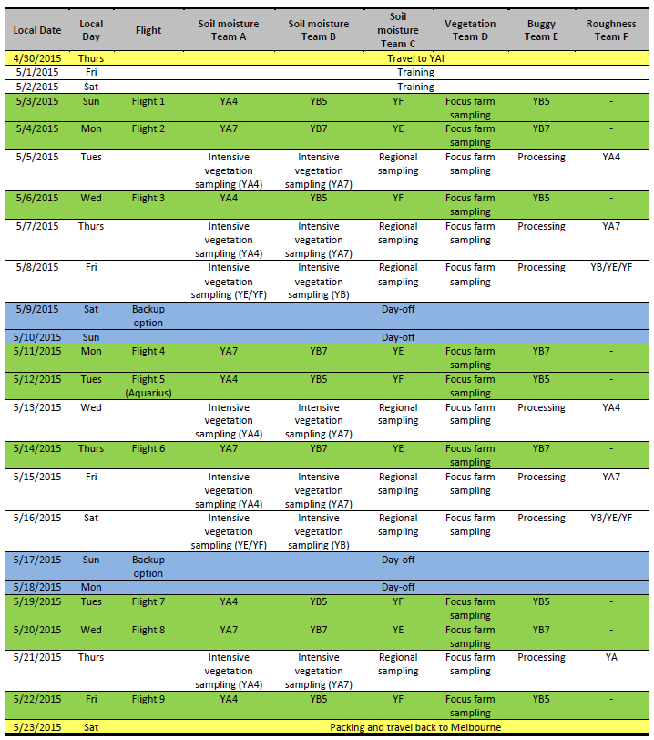
SMAPEx-4 Schedule